Interesting Cook chart of the coast of Tasmania south of Hobart with inset plan of Adventure Bay, from ‘Atlas Encyclopedique, contenant la Geographie Ancienne, et Quelques Cartes sur la Geographie du Moyen Age, la Geographie Moderne…’ by Bonne & Desmarest, Paris; folds

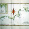
Carte de la Terre Van-Diemen. Par M.Bonne, Ingénieur Hydrographe de la Marine.
£45.00
Availability: In stock
| Year | |
|---|---|
| Cartographer | |
| Colour | |
| Dimensions (cm) | |
| Stock Reference |