1701
-
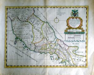
A New Map of Latium, Etruria, and as much of Antient Italy, as lay Between Gallia Cisalpina and Graecia Magna, Shewing their Principal Divisions, Cities, Towns, Rivers Mountains etc.
£50.00 Add to basketYear : 1701
Cartographer : NICHOLLS
Dimensions(in cm) : 36 x 49
Colour : Hand coloured
Stock Reference : 2109.264 -
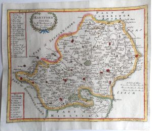 Year : 1701
Cartographer : MORDEN
Dimensions(in cm) : 17 x 21
Colour : Hand coloured
Stock Reference : 2311.024