Interesting county map showing post 1832 parliamentary boundaries from ‘A Topographical Dictionary of England…Representative History of England…’, by Samuel Lewis, published by S. Lewis & Co., 87, Aldersgate-Street, London

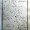
Oxfordshire
£10.00
Availability: In stock
| Year | |
|---|---|
| Cartographer | |
| Colour | |
| Dimensions (cm) | |
| Stock Reference |