Tonga: interesting Cook chart of the Friendly Islands with several small inset plans, from ‘Atlas Encyclopedique, contenant la Geographie Ancienne, et Quelques Cartes sur la Geographie du Moyen Age, la Geographie Moderne…’ by Bonne & Desmarest, Paris; folds

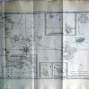
Carte des Isles des Amis. Par M. Bonne, Ingr.-Hydrogrape. de la Marine.
£25.00
| Year | |
|---|---|
| Cartographer | |
| Colour | |
| Dimensions (cm) | |
| Stock Reference |