Interesting double page folio chart of the North Polar regions with small inset map: ‘Erebus & Terror Bay in Nord Devon, Winter Quartiere Sir John Franklin 1845-46’ from ‘Hand Atlas uber Aller Theile der Erde und uber das Weltgebaude’ Gotha, Justus Perthes

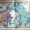
Polar-Karte enthaltend: die Lander u. Meere vom Nord-Pol bis 50 (degrees) N. Br. u. weiter, sowie Ubersicht des Russischen Reichs. Gez. v. Ad. Stieler 1832. Nachtrage v. Hrm. Bghs v 1853-1874
£15.00
Polar-Karte enthaltend: die Lander u. Meere vom Nord-Pol bis 50 (degrees) N. Br. u. weiter, sowie Ubersicht des Russischen Reichs. Gez. v. Ad. Stieler 1832. Nachtrage v. Hrm. Bghs v 1853-1874
| Year | |
|---|---|
| Cartographer | |
| Colour | |
| Dimensions (cm) | |
| Stock Reference |