Detailed double page map of parts of Normandy and Brittany, and the Channel Islands, from ‘Atlas Portatif a l’Usage des Colleges, pour Servir a l’Intelligence des Auteurs Classiques’, by Abbe Grenet, Paris

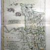
Departements et Districts de Normandie et du Maine Perche. Par M. Bonne, Ingenr. Hydrographe de la Marine. 1790.
£25.00
| Year | |
|---|---|
| Cartographer | |
| Colour | |
| Dimensions (cm) | |
| Stock Reference |