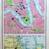
Detailed miniature town plan (Scale: 1.5 inch to 1 mile) with map of Moreton Bay below, from ‘The Handy Atlas of the British Empire’, published by George Newnes, Limited, London

Brisbane.
£8.00
Brisbane.
Availability: In stock
| Year | |
|---|---|
| Cartographer | |
| Colour | |
| Dimensions (cm) | |
| Stock Reference |